Geolocate

Puerto Pizana topographic map

Click on the map to display elevation.

About this map

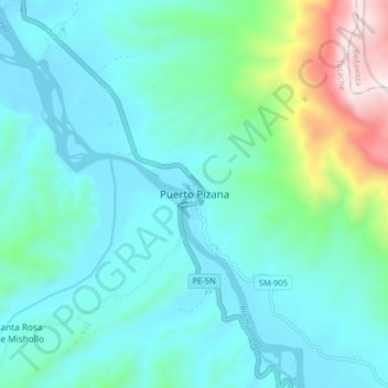
Name: Puerto Pizana topographic map, elevation, terrain.

Location: Puerto Pizana, Pólvora, Tocache, San Martín, Perú (-8.04651 -76.68746 -7.96651 -76.60746)

Average elevation: 641 m

Minimum elevation: 439 m

Maximum elevation: 1,531 m

Gear up for your next adventure:

🥾All-Terrain Hiking Boots - Versatile boots for varied hiking conditions
🧤Insulated Winter Gloves - Heavy-duty protection for sub-zero Canadian adventures
🛶Waterproof Dry Bags - Keep electronics and clothes dry during river crossings
🥾Approach Shoes - Shoes designed for climbing approaches and rugged trails
🎒Hiking Daypack - Lightweight and durable backpacks for day trips and excursions

As an Amazon Associate, this site earns from qualifying purchases at no extra cost to you.