Geolocate

Azle topographic map

Click on the map to display elevation.

About this map

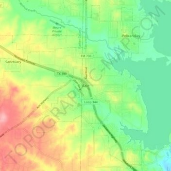
Name: Azle topographic map, elevation, terrain.

Location: Azle, Tarrant County, Texas, 76020, United States (32.85759 -97.58378 32.93759 -97.50378)

Average elevation: 224 m

Minimum elevation: 176 m

Maximum elevation: 294 m

Gear up for your next adventure:

🦶Hiking Shoe Insoles - Added support for high arches and long days on feet
🧤Thermal Hiking Gloves - Grip-enhanced gloves for cold-weather altitude trekking
🧣Evaporative Cooling Towel - Beat the heat during intense summer climbs
🧥Ultralight Puffy Jacket - Maximum warmth that packs down to the size of an orange
🥾Mountain Hiking Shoes - Shoes with superior grip for mountainous terrain

As an Amazon Associate, this site earns from qualifying purchases at no extra cost to you.