Geolocate

Allanche topographic map

Click on the map to display elevation.

About this map

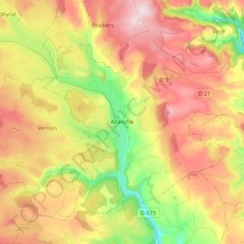
Name: Allanche topographic map, elevation, terrain.

Location: Allanche, Saint-Flour, Cantal, Auvergne-Rhône-Alpes, Metropolitan France, 15160, France (45.18962 2.88742 45.26733 3.03458)

Average elevation: 1,117 m

Minimum elevation: 903 m

Maximum elevation: 1,318 m

Other topographic maps

Click on a map to view its topography, its elevation and its terrain.

Lidar

France > Auvergne-Rhône-Alpes > Cantal > Brezons

Average elevation: 1,048 m

Super Lioran

France > Auvergne-Rhône-Alpes > Cantal

Average elevation: 1,367 m

Ramon

France > Auvergne-Rhône-Alpes > Cantal > Boisset

Average elevation: 480 m

Lidar

France > Auvergne-Rhône-Alpes > Cantal > Brezons

Average elevation: 1,048 m

Puy Mary

France > Auvergne-Rhône-Alpes > Cantal > Le Falgoux

Average elevation: 1,413 m

La Tulière

France > Auvergne-Rhône-Alpes > Cantal > Trémouille

Average elevation: 890 m

Passevite

France > Auvergne-Rhône-Alpes > Cantal > Rouziers

Average elevation: 519 m

Laborne

France > Auvergne-Rhône-Alpes > Cantal > Marcolès

Average elevation: 691 m

La Bastide

France > Auvergne-Rhône-Alpes > Cantal > Laveissière

Average elevation: 1,111 m

Gear up for your next adventure:

🧶550 Survival Paracord - Versatile utility cord for emergency repairs and rigging
💡Solar Camping Lamp - Eco-friendly lighting for campsites
💧Hydration Pack - Hands-free hydration system for long hikes
🛰️Satellite Messenger - Emergency communication for areas with no cell service
🥾Mountaineering Boots - Supportive boots for climbing and high-altitude hiking

As an Amazon Associate, this site earns from qualifying purchases at no extra cost to you.