Geolocate

Mendicino topographic map

Click on the map to display elevation.

About this map

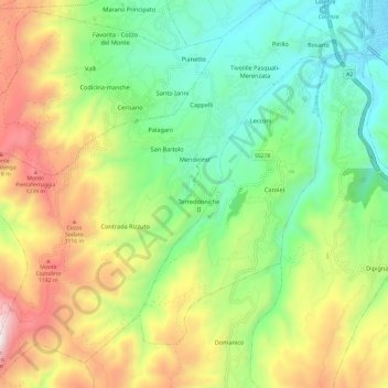
Name: Mendicino topographic map, elevation, terrain.

Location: Mendicino, Cosenza, Calabria, Italy (39.20877 16.12625 39.30176 16.24139)

Average elevation: 700 m

Minimum elevation: 233 m

Maximum elevation: 1,470 m

Other topographic maps

Click on a map to view its topography, its elevation and its terrain.

Savuto

Italy > Calabria > Cosenza > Cleto

Average elevation: 284 m

Lago dell'Esaro

Italy > Calabria > Cosenza > Roggiano Gravina

Average elevation: 156 m

Gear up for your next adventure:

🧦Merino Wool Socks - Moisture-wicking comfort for long-distance hiking
🧥Waterproof Pants - Keep dry during rainy hiking conditions
🚲Heavy Duty Bike Lock - Secure your bike at the trailhead or during stops
🔦LED Flashlight - Powerful and long-lasting flashlight for camping and emergencies
🥾Mountaineering Boots - Supportive boots for climbing and high-altitude hiking

As an Amazon Associate, this site earns from qualifying purchases at no extra cost to you.