
Make a donation
Gear up for your next adventure:
As an Amazon Associate, this site earns from qualifying purchases at no extra cost to you.
La Lagunita topographic map
Click on the map to display elevation.
Make a donation
Gear up for your next adventure:
As an Amazon Associate, this site earns from qualifying purchases at no extra cost to you.
About this map
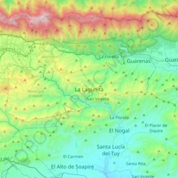
Name: La Lagunita topographic map, elevation, terrain.
Average elevation: 796 m
Minimum elevation: 122 m
Maximum elevation: 2,731 m
Make a donation
Gear up for your next adventure:
As an Amazon Associate, this site earns from qualifying purchases at no extra cost to you.
Other topographic maps
Click on a map to view its topography, its elevation and its terrain.
Make a donation
Gear up for your next adventure:
As an Amazon Associate, this site earns from qualifying purchases at no extra cost to you.
Parque Bolívar de La Carlota
Venezuela > Estado Miranda > Municipio Sucre > Caracas
Average elevation: 874 m
Petare Norte
Venezuela > Estado Miranda > Municipio Sucre > Caracas
El Centro Histórico de Petare está ubicado en la sección más oriental del Valle de Caracas, sobre una elevación de 840 m s. n. m., característica decisiva que indujo a los conquistadores españoles a escoger la plaza como sitio ideal para la fundación del pueblo de doctrina del Dulce Nombre de Jesús de…
Average elevation: 933 m
Parque Miguel José Sanz
Venezuela > Estado Miranda > Municipio Sucre > Caracas
Average elevation: 879 m
Make a donation
Gear up for your next adventure:
As an Amazon Associate, this site earns from qualifying purchases at no extra cost to you.