Geolocate

Hamlin topographic map

Click on the map to display elevation.

About this map

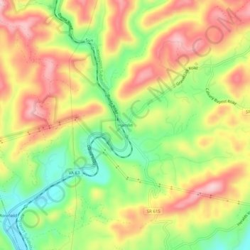
Name: Hamlin topographic map, elevation, terrain.

Location: Hamlin, Russell County, Virginia, 22442, United States (36.90816 -82.29847 36.94816 -82.25847)

Average elevation: 558 m

Minimum elevation: 446 m

Maximum elevation: 662 m

Other topographic maps

Click on a map to view its topography, its elevation and its terrain.

Honaker

United States > Virginia > Russell County

Average elevation: 620 m

Gear up for your next adventure:

🧊Portable Cooler - Keep food and drinks cold during outdoor adventures
🧢Sun Hat - Wide-brim hat for sun protection
🧴Waterproofing Spray - Restore the DWR coating on jackets and tents
🧦Outdoor Socks - Durable socks designed for hiking and outdoor sports
Lightweight Backpacking Tent - Compact tent for efficient hiking trips

As an Amazon Associate, this site earns from qualifying purchases at no extra cost to you.