Geolocate

Taha’a topographic map

Click on the map to display elevation.

About this map

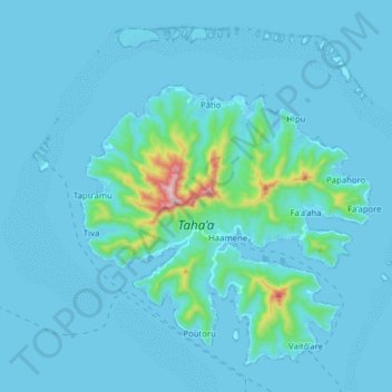
Name: Taha’a topographic map, elevation, terrain.

Location: Taha’a, Leeward Islands, French Polynesia, 98733, France (-16.68462 -151.56933 -16.55486 -151.41190)

Average elevation: 36 m

Minimum elevation: -1 m

Maximum elevation: 558 m

Other topographic maps

Click on a map to view its topography, its elevation and its terrain.

Polynesia

France > French Polynesia > Leeward Islands

Average elevation: 1 m

Manuae

France > French Polynesia > Leeward Islands

Average elevation: 0 m

Gear up for your next adventure:

💡Solar Camping Lamp - Eco-friendly lighting for campsites
🧰Survival Kit - Essential gear for emergencies in the wilderness
💧Hydration Pack - Hands-free hydration system for long hikes
🥾Trail Hiking Shoes - Durable shoes designed for rugged trails
🏕️Camping Hammock - Integrated protection for sleeping between trees

As an Amazon Associate, this site earns from qualifying purchases at no extra cost to you.