
Thank you for supporting this site ❤️
Make a donation
Make a donation
Gear up for your next adventure:
As an Amazon Associate, this site earns from qualifying purchases at no extra cost to you.
la Cellera de Ter topographic map
Click on the map to display elevation.
Thank you for supporting this site ❤️
Make a donation
Make a donation
Gear up for your next adventure:
As an Amazon Associate, this site earns from qualifying purchases at no extra cost to you.
la Cellera de Ter
Der Ort La Cellera de Ter liegt am Rand des Naturparks Les Guilleries auf 166 m Höhe, etwa 12 km entfernt von Girona.
Thank you for supporting this site ❤️
Make a donation
Make a donation
Gear up for your next adventure:
As an Amazon Associate, this site earns from qualifying purchases at no extra cost to you.
About this map
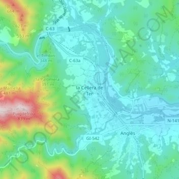
Name: la Cellera de Ter topographic map, elevation, terrain.
Location: la Cellera de Ter, la Selva, Girona, Katalonien, Spanien (41.94956 2.56165 41.98827 2.63383)
Average elevation: 274 m
Minimum elevation: 132 m
Maximum elevation: 814 m
Thank you for supporting this site ❤️
Make a donation
Make a donation
Gear up for your next adventure:
As an Amazon Associate, this site earns from qualifying purchases at no extra cost to you.