
Make a donation
Gear up for your next adventure:
As an Amazon Associate, this site earns from qualifying purchases at no extra cost to you.
Franzosenkopf topographic map
Click on the map to display elevation.
Make a donation
Gear up for your next adventure:
As an Amazon Associate, this site earns from qualifying purchases at no extra cost to you.
Franzosenkopf
Der Franzosenkopf erhebt sich im Mittelharz und im Nationalpark Harz. Sein Gipfel liegt 1,5 km nordöstlich von Lonau. Nach Norden leitet die Landschaft mit geringer Schartenhöhe zum Braakberg (645,5 m) über. Östlich und südlich umfließt die Kleine Lonau den Berg im Mariental. Westlich ist er durch das Hackenstieltal vom Kargeskopf (585 m) getrennt.
Make a donation
Gear up for your next adventure:
As an Amazon Associate, this site earns from qualifying purchases at no extra cost to you.
About this map
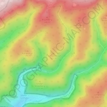
Name: Franzosenkopf topographic map, elevation, terrain.
Average elevation: 520 m
Minimum elevation: 339 m
Maximum elevation: 692 m
Make a donation
Gear up for your next adventure:
As an Amazon Associate, this site earns from qualifying purchases at no extra cost to you.