Geolocate

Centelles topographic map

Click on the map to display elevation.

👉 Easily get elevation data in JSON, GeoTIFF and KML formats using Elevation API
Thank you for supporting this site ❤️
Make a donation

About this map

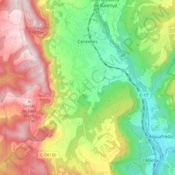
Name: Centelles topographic map, elevation, terrain.

Location: Centelles, Osona, Barcelona, Catalonia, 08540, Spain (41.75749 2.18630 41.81069 2.24979)

Average elevation: 659 m

Minimum elevation: 391 m

Maximum elevation: 993 m

Other topographic maps

Click on a map to view its topography, its elevation and its terrain.

Pla de la Calma

Spain > Catalonia > Osona > el Brull

Average elevation: 1,111 m

Gear up for your next adventure:

👖Convertible Hiking Pants - Zip-off legs to adapt to changing weather conditions
🧼Travel Hand Sanitizer - Keep hands clean when water is scarce
🧣Merino Neck Gaiter - Protects against wind, sun, and cold at high altitudes
🛌Insulated Sleeping Pad - Critical thermal barrier between you and the cold ground
🔭Compact Monocular - One-handed bird watching and trail spotting

As an Amazon Associate, this site earns from qualifying purchases at no extra cost to you.