Geolocate

Wells topographic map

Click on the map to display elevation.

Wells

According to the United States Census Bureau, the city has a total area of 6.9 square miles (18 km2), all land, at an elevation of 5,630 feet (1,720 m).

About this map

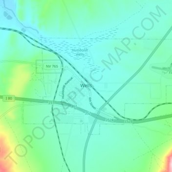
Name: Wells topographic map, elevation, terrain.

Location: Wells, Elko County, Nevada, United States (41.09325 -114.99295 41.12770 -114.91161)

Average elevation: 1,744 m

Minimum elevation: 1,695 m

Maximum elevation: 1,964 m

Other topographic maps

Click on a map to view its topography, its elevation and its terrain.

Ryndon

United States > Nevada > Elko County

Average elevation: 1,603 m

Holborn

United States > Nevada > Elko County > Holborn

Average elevation: 1,855 m

Gear up for your next adventure:

🧥Fleece Jacket - Warm and lightweight jacket for layering
💡Portable Camping Lamp - Rechargeable lamp for campsite lighting
🧤Rechargeable Heated Gloves - Extreme warmth for Canadian winter expeditions
🔥Emergency Fire Starter - Reliable ignition source for all weather conditions
🦌Outdoor Trail Camera - Monitor wildlife activity near your favorite spots

As an Amazon Associate, this site earns from qualifying purchases at no extra cost to you.