

Make a donation
Gear up for your next adventure:
As an Amazon Associate, this site earns from qualifying purchases at no extra cost to you.
Huailai County topographic map
Click on the map to display elevation.
Make a donation
Gear up for your next adventure:
As an Amazon Associate, this site earns from qualifying purchases at no extra cost to you.
Huailai County
Huailai County has a monsoon-influenced, continental semi-arid climate (Köppen BSk), with cold, dry, and windy winters and hot, humid summers, with temperatures slightly warmer than Zhangjiakou due to the more southerly location but still significantly cooler than in Beijing due to the high elevation. The monthly 24-hour average temperature ranges from −7.0 °C (19.4 °F) in January to 24.8 °C (76.6 °F) in July, and the annual mean is 10.01 °C (50.0 °F). A majority of the annual rainfall occurs in July and August alone. With monthly percent possible sunshine ranging from 60% in July to 73% in January and February, sunshine is abundant year-round, totalling about 3,030 hours annually.
Make a donation
Gear up for your next adventure:
As an Amazon Associate, this site earns from qualifying purchases at no extra cost to you.
About this map
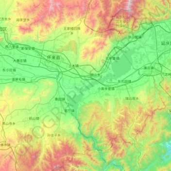
Name: Huailai County topographic map, elevation, terrain.
Location: Huailai County, Zhangjiakou City, Hebei, China (40.06413 115.27853 40.58777 115.96294)
Average elevation: 840 m
Minimum elevation: 234 m
Maximum elevation: 2,218 m
Make a donation
Gear up for your next adventure:
As an Amazon Associate, this site earns from qualifying purchases at no extra cost to you.