
Make a donation
Gear up for your next adventure:
As an Amazon Associate, this site earns from qualifying purchases at no extra cost to you.
Appenrode topographic map
Click on the map to display elevation.
Make a donation
Gear up for your next adventure:
As an Amazon Associate, this site earns from qualifying purchases at no extra cost to you.
Appenrode
Bei Appenrode befindet sich eine bereits 1589 beschriebene grottenartige Höhle, das Naturdenkmal Kelle. Die noch immer offen zugängliche Höhle besitzt im Zugangsbereich einen hallenartiger Raum von bis zu 25 Meter Höhe, 16 Meter Breite und noch 20 Meter Resttiefe, vor einem Teileinsturz durch fortdauernde Verwitterung im 19. Jahrhundert war diese Halle 95 Meter tief. Am Grund der Höhle befindet sich ein kleiner Höhlensee, dieser besitzt eine maximale Tiefe von 5 Meter. Die Höhle war schon vor zweihundert Jahren eine bekannte Sehenswürdigkeit und wurde auch von Gottfried August Bürger, Johann Wilhelm Gleim und Christoph August Tiedge aufgesucht.
Make a donation
Gear up for your next adventure:
As an Amazon Associate, this site earns from qualifying purchases at no extra cost to you.
About this map
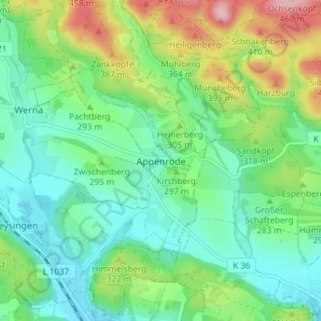
Name: Appenrode topographic map, elevation, terrain.
Average elevation: 286 m
Minimum elevation: 217 m
Maximum elevation: 448 m
Make a donation
Gear up for your next adventure:
As an Amazon Associate, this site earns from qualifying purchases at no extra cost to you.