
Make a donation
Gear up for your next adventure:
As an Amazon Associate, this site earns from qualifying purchases at no extra cost to you.
Oak Park topographic map
Click on the map to display elevation.
Make a donation
Gear up for your next adventure:
As an Amazon Associate, this site earns from qualifying purchases at no extra cost to you.
About this map
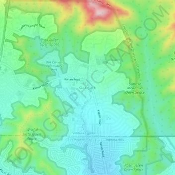
Name: Oak Park topographic map, elevation, terrain.
Average elevation: 378 m
Minimum elevation: 281 m
Maximum elevation: 638 m
Make a donation
Gear up for your next adventure:
As an Amazon Associate, this site earns from qualifying purchases at no extra cost to you.
Other topographic maps
Click on a map to view its topography, its elevation and its terrain.
Camarillo
United States > California > Ventura County
In the mid-1950s, the Ventura Freeway was completed from Los Angeles to points north, making it an easy one-hour trip to Camarillo. The Old Town was bisect by the Ventura Freeway. On the southern side of the freeway contains a strip of businesses, churches, schools, and parks. The freeway was originally…
Average elevation: 90 m
Thousand Oaks
United States > California > Ventura County
The northern parts consist of mountainous terrain in the Simi Hills, Conejo Mountains and Mount Clef Ridge. Narrow canyons such as Hill Canyon cut through the steeper mountainous areas. Conejo Mountain and Conejo Grade are found in westernmost Newbury Park, while the southernmost parts of Thousand Oaks are…
Average elevation: 333 m
Make a donation
Gear up for your next adventure:
As an Amazon Associate, this site earns from qualifying purchases at no extra cost to you.