
Thank you for supporting this site ❤️
Make a donation
Make a donation
Gear up for your next adventure:
As an Amazon Associate, this site earns from qualifying purchases at no extra cost to you.
Mazatenango topographic map
Click on the map to display elevation.
Thank you for supporting this site ❤️
Make a donation
Make a donation
Gear up for your next adventure:
As an Amazon Associate, this site earns from qualifying purchases at no extra cost to you.
About this map
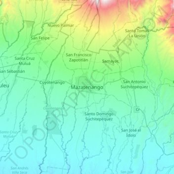
Name: Mazatenango topographic map, elevation, terrain.
Location: Mazatenango, Suchitepéquez, 10001, Guatemala (14.37315 -91.66600 14.69315 -91.34600)
Average elevation: 472 m
Minimum elevation: 62 m
Maximum elevation: 2,414 m
Thank you for supporting this site ❤️
Make a donation
Make a donation
Gear up for your next adventure:
As an Amazon Associate, this site earns from qualifying purchases at no extra cost to you.