Geolocate

Paloh topographic map

Click on the map to display elevation.

About this map

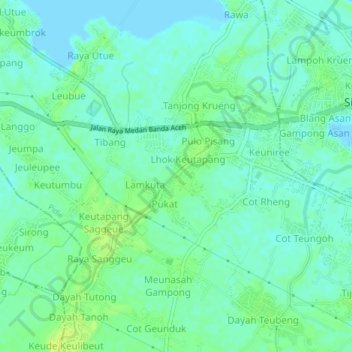
Name: Paloh topographic map, elevation, terrain.

Location: Paloh, Pidie, Aceh, Sumatra, 24151, Indonesia (5.35286 95.91749 5.39286 95.95749)

Average elevation: 6 m

Minimum elevation: -2 m

Maximum elevation: 15 m

Other topographic maps

Click on a map to view its topography, its elevation and its terrain.

Sakti

Indonesia > Aceh > Pidie

Average elevation: 39 m

Simpang Tiga

Indonesia > Aceh > Pidie

Average elevation: 5 m

Geumpang

Indonesia > Aceh > Pidie

Average elevation: 1,196 m

Sakti

Indonesia > Aceh > Pidie

Average elevation: 39 m

Gear up for your next adventure:

🥾Hiking Boots - Sturdy boots providing ankle support and traction on rugged trails
🥾Trail Hiking Socks - Comfortable socks to prevent blisters and fatigue
🛶Kayak Dry Bag - Waterproof storage for kayaking adventures
🥾Hiking Leggings - Comfortable leggings for outdoor activities
🧦Hiking Liner Socks - Thin base layer to prevent friction and blisters

As an Amazon Associate, this site earns from qualifying purchases at no extra cost to you.