Geolocate

Olive topographic map

Click on the map to display elevation.

About this map

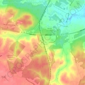
Name: Olive topographic map, elevation, terrain.

Location: Olive, Spotsylvania County, Virginia, 22408, United States (38.19957 -77.46109 38.23957 -77.42109)

Average elevation: 48 m

Minimum elevation: 5 m

Maximum elevation: 79 m

Gear up for your next adventure:

🧢Sun Protection Cap - Breathable cap to protect from sun exposure
🧦Thermal Socks - Warm socks for winter hiking or camping
🦶Anti-Blister Balm - Prevents friction and hotspots during long ascents
🔥Camping Stove - Portable stoves to cook outdoors with ease
🥘Camping Cookware Set - Compact nesting pots and pans for trail cooking

As an Amazon Associate, this site earns from qualifying purchases at no extra cost to you.