Geolocate

Kevadia topographic map

Click on the map to display elevation.

About this map

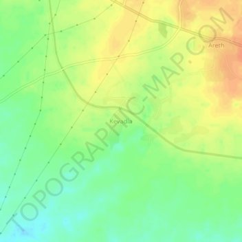
Name: Kevadia topographic map, elevation, terrain.

Location: Kevadia, Mandvi Taluka, Surat, Gujarat, 394163, India (21.27477 73.12724 21.31477 73.16724)

Average elevation: 41 m

Minimum elevation: 21 m

Maximum elevation: 59 m

Other topographic maps

Click on a map to view its topography, its elevation and its terrain.

Mandvi Taluka

India > Gujarat > Mandvi Taluka

Average elevation: 73 m

Gear up for your next adventure:

🧥Softshell Jacket - Windproof and breathable jacket for hiking
🧥Waterproof Pants - Keep dry during rainy hiking conditions
🦌Outdoor Trail Camera - Monitor wildlife activity near your favorite spots
🥾Light Hiking Boots - Lightweight and comfortable boots for day hikes
Tent Footprint - Protect tent floor and increase durability

As an Amazon Associate, this site earns from qualifying purchases at no extra cost to you.