
Make a donation
Gear up for your next adventure:
As an Amazon Associate, this site earns from qualifying purchases at no extra cost to you.
Schärding topographic map
Click on the map to display elevation.
Make a donation
Gear up for your next adventure:
As an Amazon Associate, this site earns from qualifying purchases at no extra cost to you.
Schärding
The town sits at an altitude of 313 meters and is located in the Innviertel. It measures 4.1 kilometers from north to south, 1.9 km from west to east. The total area is 4.08 km². 2.4 percent of the area is forested, 31.7 percent is used for agriculture.
Make a donation
Gear up for your next adventure:
As an Amazon Associate, this site earns from qualifying purchases at no extra cost to you.
About this map
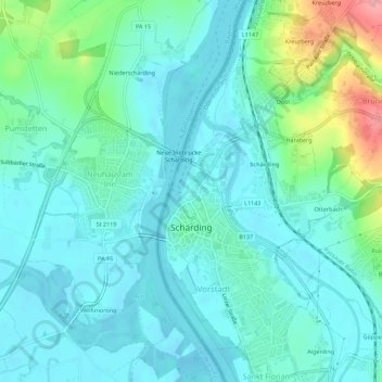
Name: Schärding topographic map, elevation, terrain.
Location: Schärding, Bezirk Schärding, Upper Austria, 4780, Austria (48.44212 13.42690 48.47889 13.45229)
Average elevation: 323 m
Minimum elevation: 301 m
Maximum elevation: 410 m
Make a donation
Gear up for your next adventure:
As an Amazon Associate, this site earns from qualifying purchases at no extra cost to you.
Other topographic maps
Click on a map to view its topography, its elevation and its terrain.