Geolocate

Mammoth Spring topographic map

Click on the map to display elevation.

About this map

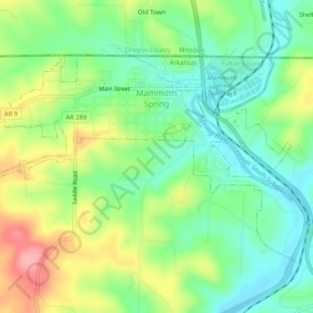
Name: Mammoth Spring topographic map, elevation, terrain.

Location: Mammoth Spring, Fulton County, Arkansas, United States (36.47730 -91.56491 36.49926 -91.52289)

Average elevation: 186 m

Minimum elevation: 144 m

Maximum elevation: 254 m

Other topographic maps

Click on a map to view its topography, its elevation and its terrain.

Elizabeth

United States > Arkansas > Fulton County

Average elevation: 233 m

Gear up for your next adventure:

💡Portable Camping Lamp - Rechargeable lamp for campsite lighting
🥾All-Terrain Hiking Boots - Versatile boots for varied hiking conditions
🛌Insulated Sleeping Pad - Critical thermal barrier between you and the cold ground
🧦Crew Hiking Socks - Comfortable socks for long-distance hikes
🧴Outdoor Sunscreen - High SPF protection for high-altitude UV exposure

As an Amazon Associate, this site earns from qualifying purchases at no extra cost to you.