
Make a donation
Gear up for your next adventure:
As an Amazon Associate, this site earns from qualifying purchases at no extra cost to you.
Itterbeek topographic map
Click on the map to display elevation.
Make a donation
Gear up for your next adventure:
As an Amazon Associate, this site earns from qualifying purchases at no extra cost to you.
Itterbeek
Itterbeek ligt aan de rand van de Brusselse agglomeratie op een hoogte van 33-77 meter. In het zuiden stroomt de Neerpedebeek in oostelijke richting. Een belangrijk natuurgebied is het Begijnenborrebos.
Make a donation
Gear up for your next adventure:
As an Amazon Associate, this site earns from qualifying purchases at no extra cost to you.
About this map
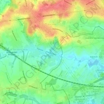
Name: Itterbeek topographic map, elevation, terrain.
Average elevation: 51 m
Minimum elevation: 23 m
Maximum elevation: 88 m
Make a donation
Gear up for your next adventure:
As an Amazon Associate, this site earns from qualifying purchases at no extra cost to you.
Other topographic maps
Click on a map to view its topography, its elevation and its terrain.
Sint-Gertrudis-Pede
België > Vlaams-Brabant > Halle-Vilvoorde > Dilbeek
Sint-Gertrudis-Pede ligt aan de Pedebeek op een hoogte van ongeveer 35 meter. Men kan er de Pedemolenwandeling maken.
Average elevation: 56 m