
Thank you for supporting this site ❤️
Make a donation
Make a donation
Gear up for your next adventure:
As an Amazon Associate, this site earns from qualifying purchases at no extra cost to you.
Bazovik topographic map
Click on the map to display elevation.
Thank you for supporting this site ❤️
Make a donation
Make a donation
Gear up for your next adventure:
As an Amazon Associate, this site earns from qualifying purchases at no extra cost to you.
About this map
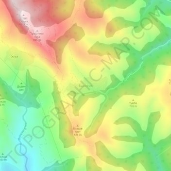
Name: Bazovik topographic map, elevation, terrain.
Location: Bazovik, Pirot Administrative District, Central Serbia, Serbia (43.28432 22.42748 43.32432 22.46748)
Average elevation: 721 m
Minimum elevation: 470 m
Maximum elevation: 1,008 m
Thank you for supporting this site ❤️
Make a donation
Make a donation
Gear up for your next adventure:
As an Amazon Associate, this site earns from qualifying purchases at no extra cost to you.