
محافظة البدع topographic map
Interactive map
Click on the map to display elevation.
About this map
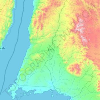
Name: محافظة البدع topographic map, elevation, terrain.
Location: محافظة البدع, Provinz Tabuk, Saudi-Arabien (28.02065 34.57103 28.92869 35.40483)
Average elevation: 483 m
Minimum elevation: -1 m
Maximum elevation: 2,512 m
Other topographic maps
Click on a map to view its topography, its elevation and its terrain.
Duba
Duba, Gouvernorat Duba, Provinz Tabuk, Saudi-Arabien
Average elevation: 61 m
Neom
Neom, Gouvernorat Duba, Provinz Tabuk, Saudi-Arabien
Average elevation: 52 m
محافظة الوجه
محافظة الوجه, Provinz Tabuk, Saudi-Arabien
Average elevation: 467 m
Gouvernement Tabuk
Gouvernement Tabuk, Provinz Tabuk, Saudi-Arabien
Average elevation: 816 m
Tabuk
Tabuk, Gouvernement Tabuk, Provinz Tabuk, 71411, Saudi-Arabien
Average elevation: 775 m