
Make a donation
Gear up for your next adventure:
As an Amazon Associate, this site earns from qualifying purchases at no extra cost to you.
Los Patios topographic map
Click on the map to display elevation.
Make a donation
Gear up for your next adventure:
As an Amazon Associate, this site earns from qualifying purchases at no extra cost to you.
About this map
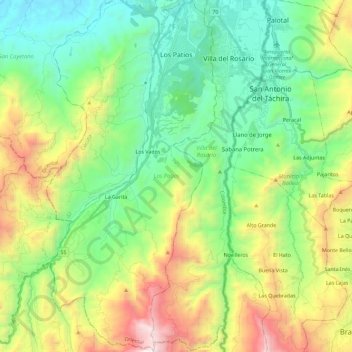
Name: Los Patios topographic map, elevation, terrain.
Location: Los Patios, Oriental, Norte de Santander, Colombia (7.64230 -72.58760 7.86937 -72.47956)
Average elevation: 842 m
Minimum elevation: 227 m
Maximum elevation: 2,130 m
Make a donation
Gear up for your next adventure:
As an Amazon Associate, this site earns from qualifying purchases at no extra cost to you.
Other topographic maps
Click on a map to view its topography, its elevation and its terrain.
Make a donation
Gear up for your next adventure:
As an Amazon Associate, this site earns from qualifying purchases at no extra cost to you.
Villa del Rosario
Colombia > Norte de Santander > Villa del Rosario > Villa del Rosario
Average elevation: 437 m