Geolocate

Quebrada topographic map

Click on the map to display elevation.

About this map

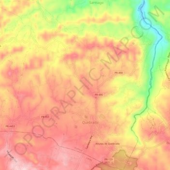
Name: Quebrada topographic map, elevation, terrain.

Location: Quebrada, Camuy, Puerto Rico, United States (18.34328 -66.86986 18.39914 -66.81237)

Average elevation: 278 m

Minimum elevation: 113 m

Maximum elevation: 370 m

Other topographic maps

Click on a map to view its topography, its elevation and its terrain.

Camuy

United States > Puerto Rico > Camuy > Camuy

Average elevation: 42 m

Gear up for your next adventure:

📷Outdoor Action Camera - Capture high-elevation views and rugged adventures
🥾Trail Hiking Socks - Comfortable socks to prevent blisters and fatigue
👟Trail Running Shoes - Agile footwear for fast-paced topographic exploration
🧤Rechargeable Heated Gloves - Extreme warmth for Canadian winter expeditions
🎒Backpack Rain Cover - External shield to keep your entire pack dry

As an Amazon Associate, this site earns from qualifying purchases at no extra cost to you.