Geolocate

Cutervo topographic map

Click on the map to display elevation.

About this map

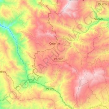
Name: Cutervo topographic map, elevation, terrain.

Location: Cutervo, Province of Cutervo, Cajamarca, Peru (-6.55007 -78.99521 -6.26666 -78.71100)

Average elevation: 2,429 m

Minimum elevation: 1,289 m

Maximum elevation: 3,500 m

Gear up for your next adventure:

🥾Mountain Trail Shoes - High-traction shoes for mountain trails
🚲Bike Repair Kit - Essential tools for on-trail mechanical issues
🧦Hiking Socks - Moisture-wicking and comfortable socks for long hikes
🧥Packable Rain Jacket - Breathable waterproof layer for unpredictable weather
🔪Outdoor Multitool - Versatile tool for repairs and food prep in the wild

As an Amazon Associate, this site earns from qualifying purchases at no extra cost to you.