
Rostock topographic map
Click on the map to display elevation.
About this map
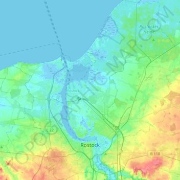
Name: Rostock topographic map, elevation, terrain.
Location: Rostock, Mecklenburg-Vorpommern, Germany (54.05081 11.99837 54.24450 12.29540)
Average elevation: 14 m
Minimum elevation: -4 m
Maximum elevation: 69 m
Other topographic maps
Click on a map to view its topography, its elevation and its terrain.
Mürgen
Germany > Mecklenburg-Vorpommern > Mecklenburgische Seenplatte > Schwichtenberg
Average elevation: 10 m