Geolocate

El Tambo topographic map

Click on the map to display elevation.

About this map

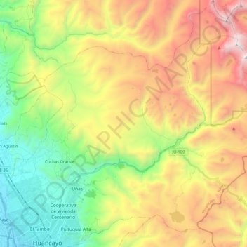
Name: El Tambo topographic map, elevation, terrain.

Location: El Tambo, Province of Huancayo, Junín, Peru (-12.07153 -75.24740 -11.87256 -75.05347)

Average elevation: 4,165 m

Minimum elevation: 3,184 m

Maximum elevation: 5,523 m

Other topographic maps

Click on a map to view its topography, its elevation and its terrain.

Vista Alegre

Peru > Junín > Tarma

Average elevation: 3,287 m

Gear up for your next adventure:

🧰Multitool Knife - Compact and versatile tool for outdoor use
Camping Tent - Weather-resistant tents suitable for 2 to 6 people
🛌Insulated Sleeping Pad - Critical thermal barrier between you and the cold ground
🌡️Emergency Mylar Blankets - Compact thermal protection for unexpected nights outdoors
🧢Hiking Sun Hat - Wide-brimmed protection for exposed mountain ridges

As an Amazon Associate, this site earns from qualifying purchases at no extra cost to you.