
Thank you for supporting this site ❤️
Make a donation
Make a donation
Gear up for your next adventure:
As an Amazon Associate, this site earns from qualifying purchases at no extra cost to you.
Vendrogno topographic map
Click on the map to display elevation.
Thank you for supporting this site ❤️
Make a donation
Make a donation
Gear up for your next adventure:
As an Amazon Associate, this site earns from qualifying purchases at no extra cost to you.
About this map
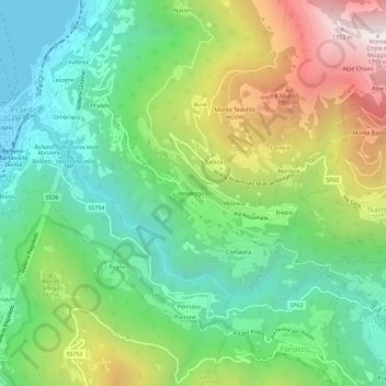
Name: Vendrogno topographic map, elevation, terrain.
Location: Vendrogno, Bellano, Lecco, Lombardia, 23822, Italia (46.01439 9.30944 46.05439 9.34944)
Average elevation: 760 m
Minimum elevation: 197 m
Maximum elevation: 1,788 m
Thank you for supporting this site ❤️
Make a donation
Make a donation
Gear up for your next adventure:
As an Amazon Associate, this site earns from qualifying purchases at no extra cost to you.