
Make a donation
Gear up for your next adventure:
As an Amazon Associate, this site earns from qualifying purchases at no extra cost to you.
Embalse de Santillana topographic map
Click on the map to display elevation.
Make a donation
Gear up for your next adventure:
As an Amazon Associate, this site earns from qualifying purchases at no extra cost to you.
About this map
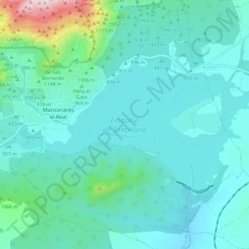
Name: Embalse de Santillana topographic map, elevation, terrain.
Average elevation: 955 m
Minimum elevation: 851 m
Maximum elevation: 1,560 m
Make a donation
Gear up for your next adventure:
As an Amazon Associate, this site earns from qualifying purchases at no extra cost to you.
Other topographic maps
Click on a map to view its topography, its elevation and its terrain.
Make a donation
Gear up for your next adventure:
As an Amazon Associate, this site earns from qualifying purchases at no extra cost to you.
Pilancones en la zona del Mirador del Tranco, en la Pedriza de Manzanares
España > Comunidad de Madrid > Manzanares el Real
Average elevation: 1,160 m
Tafoni en panal de la cara este de la 5ª Buitrera, en la Pedriza de Manzanares
España > Comunidad de Madrid > Manzanares el Real
Average elevation: 1,480 m