
Waikaia topographic map
Click on the map to display elevation.
About this map
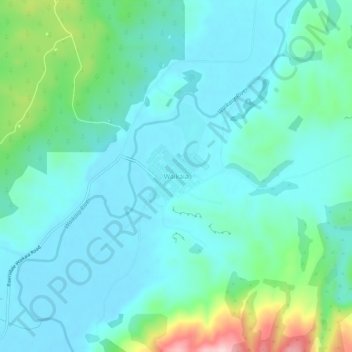
Name: Waikaia topographic map, elevation, terrain.
Location: Waikaia, Southland District, Southland, 9745, New Zealand (-45.74533 168.83001 -45.70533 168.87001)
Average elevation: 207 m
Minimum elevation: 155 m
Maximum elevation: 421 m
Other topographic maps
Click on a map to view its topography, its elevation and its terrain.
Lake Quill
New Zealand > Southland > Southland District > Fiordland Community
Average elevation: 1,228 m
Stewart Island / Rakiura Community
New Zealand > Southland > Southland District
Average elevation: 63 m
Doubtful Sound
New Zealand > Southland > Southland District > Fiordland Community
Average elevation: 560 m
Takitimu Mountains
New Zealand > Southland > Southland District > Wallace Takitimu Community
Average elevation: 828 m
Te Puhi-a-noa / Murchison Mountains
New Zealand > Southland > Southland District
Average elevation: 851 m
Darran Mountains
New Zealand > Southland > Southland District > Fiordland Community
Average elevation: 911 m
Skippers Range
New Zealand > Southland > Southland District > Fiordland Community
Average elevation: 595 m
Te Rau / Garvie Mountains
New Zealand > Southland > Southland District > Cromwell Community
Average elevation: 1,393 m
Wick Mountains
New Zealand > Southland > Southland District > Fiordland Community
Average elevation: 1,185 m
Mararoa River
New Zealand > Southland > Southland District > Fiordland Community
Average elevation: 681 m
Waikawa River
New Zealand > Southland > Southland District > Waihopai Toetoe Community
Average elevation: 134 m
Lake Te Au
New Zealand > Southland > Southland District > Fiordland Community
Average elevation: 597 m
Donne Glacier
New Zealand > Southland > Southland District > Fiordland Community
Average elevation: 1,826 m
Age Glacier
New Zealand > Southland > Southland District > Fiordland Community
Average elevation: 1,753 m
Eyre Mountains / Taka Ra Haka Conservation Park
New Zealand > Southland > Southland District
Average elevation: 810 m
Wild Natives River
New Zealand > Southland > Southland District > Fiordland Community
Average elevation: 769 m
Lake Innes
New Zealand > Southland > Southland District > Tuatapere Te Waewae Community
Average elevation: 223 m
Cleddau River
New Zealand > Southland > Southland District > Fiordland Community
Average elevation: 800 m
Pembroke Glacier
New Zealand > Southland > Southland District > Fiordland Community
Average elevation: 1,211 m
Pitt River
New Zealand > Southland > Southland District > Fiordland Community
Average elevation: 706 m