Geolocate

Kauru topographic map

Click on the map to display elevation.

About this map

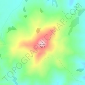
Name: Kauru topographic map, elevation, terrain.

Location: Kauru, Waitaki District, Otago, New Zealand (-45.09313 170.70985 -45.09303 170.70995)

Average elevation: 264 m

Minimum elevation: 162 m

Maximum elevation: 456 m

Other topographic maps

Click on a map to view its topography, its elevation and its terrain.

Kakanui Mountains

New Zealand > Otago > Waitaki District

Average elevation: 784 m

Kakanui River

New Zealand > Otago > Waitaki District

Average elevation: 315 m

Pleasant River

New Zealand > Otago > Waitaki District

Average elevation: 108 m

Gear up for your next adventure:

🛶Kayak Accessories - Essential gear for safe and fun kayaking adventures
🧢Hiking Sun Hat - Wide-brimmed protection for exposed mountain ridges
🚑Survival Whistle - Signal for help across long distances in mountains
🧢Sun Hat - Wide-brim hat for sun protection
🧦Hiking Socks - Moisture-wicking and comfortable socks for long hikes

As an Amazon Associate, this site earns from qualifying purchases at no extra cost to you.