
旌德县 topographic map
Interactive map
Click on the map to display elevation.
About this map
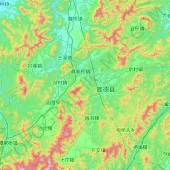
Name: 旌德县 topographic map, elevation, terrain.
Location: 旌德县, 宣城市, 安徽省, 中国 (30.12079 118.25275 30.49373 118.73712)
Average elevation: 391 m
Minimum elevation: 73 m
Maximum elevation: 1,367 m
Other topographic maps
Click on a map to view its topography, its elevation and its terrain.