Geolocate

Mercer topographic map

Click on the map to display elevation.

About this map

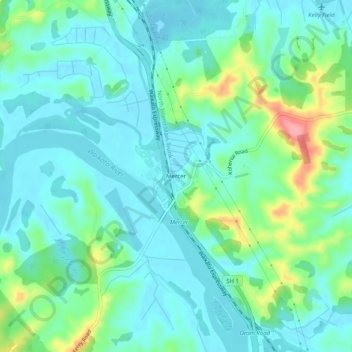
Name: Mercer topographic map, elevation, terrain.

Location: Mercer, Waikato District, Waikato, 2474, New Zealand (-37.29657 175.02850 -37.25657 175.06850)

Average elevation: 28 m

Minimum elevation: 3 m

Maximum elevation: 113 m

Other topographic maps

Click on a map to view its topography, its elevation and its terrain.

Hūnua Ranges

New Zealand > Waikato > Waikato District

Average elevation: 176 m

Lake Kimihia

New Zealand > Waikato > Waikato District

Average elevation: 34 m

Lake Whangape

New Zealand > Waikato > Waikato District

Average elevation: 16 m

Lake Rotokauri

New Zealand > Waikato > Waikato District

Average elevation: 35 m

Lake E

New Zealand > Waikato > Waikato District

Average elevation: 39 m

Gear up for your next adventure:

🥾Trail Hiking Socks - Comfortable socks to prevent blisters and fatigue
🥾Mountain Trail Shoes - High-traction shoes for mountain trails
🛁Quick-Dry Microfiber Towel - Space-saving towel that dries rapidly on the move
🕶️Polarized Sunglasses - Protect your eyes with durable polarized lenses
🔥Emergency Fire Starter - Reliable ignition source for all weather conditions

As an Amazon Associate, this site earns from qualifying purchases at no extra cost to you.