Geolocate

Ratekau topographic map

Click on the map to display elevation.

About this map

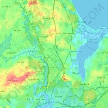
Name: Ratekau topographic map, elevation, terrain.

Location: Ratekau, Ostholstein, Schleswig-Holstein, Germany (53.91494 10.66061 54.01812 10.85061)

Average elevation: 20 m

Minimum elevation: -4 m

Maximum elevation: 73 m

Other topographic maps

Click on a map to view its topography, its elevation and its terrain.

Gear up for your next adventure:

🐕Hiking Dog Pack - Let your canine companion carry their own water and food
🪑Insulated Seat Pad - Protect your seat from cold rocks and wet logs
🧦Hiking Liner Socks - Thin base layer to prevent friction and blisters
🔥Emergency Fire Starter - Reliable ignition source for all weather conditions
🔦LED Headlamp - Hands-free lighting for early morning starts or late finishes

As an Amazon Associate, this site earns from qualifying purchases at no extra cost to you.