
Make a donation
Gear up for your next adventure:
As an Amazon Associate, this site earns from qualifying purchases at no extra cost to you.
Haute-Bodeux topographic map
Click on the map to display elevation.
Make a donation
Gear up for your next adventure:
As an Amazon Associate, this site earns from qualifying purchases at no extra cost to you.
About this map
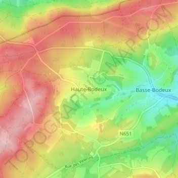
Name: Haute-Bodeux topographic map, elevation, terrain.
Average elevation: 423 m
Minimum elevation: 311 m
Maximum elevation: 529 m
Make a donation
Gear up for your next adventure:
As an Amazon Associate, this site earns from qualifying purchases at no extra cost to you.
Other topographic maps
Click on a map to view its topography, its elevation and its terrain.
Eupen
Eupen has a cool oceanic climate with some continental influences due to it being elevated in comparison to most of Belgium. Eupen is also wetter and cloudier than Liège in the valley to the west, as a result of orographic lift due to the elevation change. As a result of this along with frequent winter…
Average elevation: 368 m