
Make a donation
Gear up for your next adventure:
As an Amazon Associate, this site earns from qualifying purchases at no extra cost to you.
Idensen topographic map
Click on the map to display elevation.
Make a donation
Gear up for your next adventure:
As an Amazon Associate, this site earns from qualifying purchases at no extra cost to you.
About this map
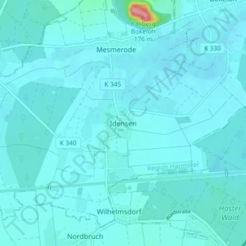
Name: Idensen topographic map, elevation, terrain.
Average elevation: 51 m
Minimum elevation: 42 m
Maximum elevation: 162 m
Make a donation
Gear up for your next adventure:
As an Amazon Associate, this site earns from qualifying purchases at no extra cost to you.
Other topographic maps
Click on a map to view its topography, its elevation and its terrain.
Steinhude
Deutschland > Niedersachsen > Region Hannover > Wunstorf
Besondere Höhepunkte sind der Fischerkreidag am Wochenende nach Christi Himmelfahrt, das Schützenfest im Juli und das Festliche Wochenende im August mit einem Feuerwerk über dem Steinhuder Meer und einem illuminierten Bootskorso („Steinhuder Meer in Flammen“). Im Dezember gibt es einen Weihnachtsmarkt.
Average elevation: 43 m