Geolocate

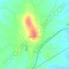
Frankston topographic map

Click on the map to display elevation.

About this map

Name: Frankston topographic map, elevation, terrain.

Location: Frankston, Anderson County, Texas, United States (32.04221 -95.52145 32.07500 -95.48813)

Average elevation: 131 m

Minimum elevation: 92 m

Maximum elevation: 188 m

Other topographic maps

Click on a map to view its topography, its elevation and its terrain.
Pineywoods Lake

United States > Texas > Anderson County

Average elevation: 143 m

Fosterville

United States > Texas > Anderson County

Average elevation: 133 m

Daly Mountain

United States > Texas > Anderson County > Neches

Average elevation: 128 m

Gear up for your next adventure:

🧦Hiking Liner Socks - Thin base layer to prevent friction and blisters
🥾Trail Running Shoes - Lightweight and durable shoes for trail running
🔭Compact Monocular - One-handed bird watching and trail spotting
🔭Outdoor Binoculars - Lightweight binoculars for birdwatching and hiking
🥾Approach Boots - Comfortable boots for hiking and climbing approaches

As an Amazon Associate, this site earns from qualifying purchases at no extra cost to you.