
Make a donation
Gear up for your next adventure:
As an Amazon Associate, this site earns from qualifying purchases at no extra cost to you.
Bramstedt topographic map
Click on the map to display elevation.
Make a donation
Gear up for your next adventure:
As an Amazon Associate, this site earns from qualifying purchases at no extra cost to you.
Bramstedt
Aus dem Jahr 1189 stammt die erste amtliche Urkunde über das Bestehen des Ortes. Damit gehört Bramstedt zu den ältesten Siedlungen im hiesigen Landkreis. Seinen Namen hat der Ort von dem Bram (= Schafginster), der neben Nadelwald und Heide auf den höher gelegenen Stellen wuchs – im Gegensatz zu den Niederungen, wo der Laubwald vorherrschte.
Make a donation
Gear up for your next adventure:
As an Amazon Associate, this site earns from qualifying purchases at no extra cost to you.
About this map
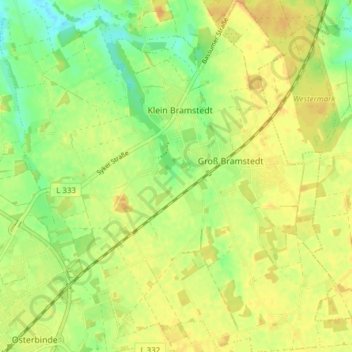
Name: Bramstedt topographic map, elevation, terrain.
Average elevation: 46 m
Minimum elevation: 29 m
Maximum elevation: 57 m
Make a donation
Gear up for your next adventure:
As an Amazon Associate, this site earns from qualifying purchases at no extra cost to you.
Other topographic maps
Click on a map to view its topography, its elevation and its terrain.
Fesenfeld
Deutschland > Niedersachsen > Landkreis Diepholz > Bassum > Nordwohlde
Average elevation: 33 m
Make a donation
Gear up for your next adventure:
As an Amazon Associate, this site earns from qualifying purchases at no extra cost to you.