Geolocate

Oxted topographic map

Click on the map to display elevation.

About this map

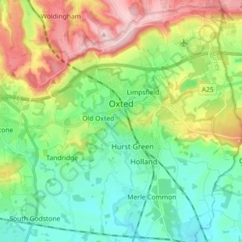
Name: Oxted topographic map, elevation, terrain.

Location: Oxted, Tandridge, Surrey, England, United Kingdom (51.21233 -0.03626 51.28976 0.01667)

Average elevation: 128 m

Minimum elevation: 54 m

Maximum elevation: 271 m

Other topographic maps

Click on a map to view its topography, its elevation and its terrain.

Starborough Castle

United Kingdom > England > Surrey > Tandridge

Average elevation: 58 m

Gear up for your next adventure:

🎒Fully Waterproof Backpack - Total protection for photography gear and electronics
🧥Softshell Hiking Jacket - The perfect balance of wind protection and breathability
🧦Outdoor Socks - Durable socks designed for hiking and outdoor sports
❄️Traction Ice Cleats - Slip-on spikes for icy trails and winter hiking
🧭GPS Handheld Device - Reliable GPS navigation for outdoor adventures

As an Amazon Associate, this site earns from qualifying purchases at no extra cost to you.