
Karacaahmet topographic map
Interactive map
Click on the map to display elevation.
About this map
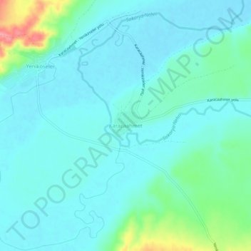
Name: Karacaahmet topographic map, elevation, terrain.
Location: Karacaahmet, Polatlı, Ankara, Central Anatolia Region, Turkey (39.70711 31.92638 39.74711 31.96638)
Average elevation: 683 m
Minimum elevation: 666 m
Maximum elevation: 760 m
Other topographic maps
Click on a map to view its topography, its elevation and its terrain.
Yassıhüyük
Yassıhüyük, Polatlı, Ankara, Central Anatolia Region, Turkey
Average elevation: 698 m