Geolocate

Maldunge topographic map

Click on the map to display elevation.

About this map

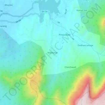
Name: Maldunge topographic map, elevation, terrain.

Location: Maldunge, Panvel Taluka, Raigad, Maharashtra, India (18.99459 73.22791 19.03459 73.26791)

Average elevation: 221 m

Minimum elevation: 61 m

Maximum elevation: 775 m

Other topographic maps

Click on a map to view its topography, its elevation and its terrain.

Central Park

India > Maharashtra > Panvel Taluka > Panvel

Average elevation: 25 m

Nere

India > Maharashtra > Panvel Taluka

Average elevation: 28 m

Gear up for your next adventure:

🌬️Windproof Camp Stove - Efficient cooking even on exposed mountain peaks
🔭Compact Binoculars - Lightweight optics for scouting trails and wildlife
🏃Hydration Running Vest - Carry water and maps close to your body for speed
🧣Evaporative Cooling Towel - Beat the heat during intense summer climbs
🧢Beanie Hat - Keep your head warm in cold weather

As an Amazon Associate, this site earns from qualifying purchases at no extra cost to you.