Geolocate

Makawao topographic map

Click on the map to display elevation.

About this map

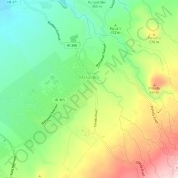
Name: Makawao topographic map, elevation, terrain.

Location: Makawao, Maui County, Hawaii, 96768, United States (20.83003 -156.34403 20.87215 -156.30157)

Average elevation: 524 m

Minimum elevation: 340 m

Maximum elevation: 798 m

Gear up for your next adventure:

🛶Kayak Dry Bag - Waterproof storage for kayaking adventures
🔦UV Flashlight - Detect minerals or specific insects in the dark
🛶Kayak Accessories - Essential gear for safe and fun kayaking adventures
🚲Bike Repair Kit - Essential tools for on-trail mechanical issues
🚲Handlebar Phone Mount - View topographic-map.com live while cycling

As an Amazon Associate, this site earns from qualifying purchases at no extra cost to you.