
Make a donation
Gear up for your next adventure:
As an Amazon Associate, this site earns from qualifying purchases at no extra cost to you.
Villa Serrano topographic map
Click on the map to display elevation.
Make a donation
Gear up for your next adventure:
As an Amazon Associate, this site earns from qualifying purchases at no extra cost to you.
About this map
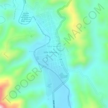
Name: Villa Serrano topographic map, elevation, terrain.
Average elevation: 2,177 m
Minimum elevation: 2,087 m
Maximum elevation: 2,385 m
Make a donation
Gear up for your next adventure:
As an Amazon Associate, this site earns from qualifying purchases at no extra cost to you.
Other topographic maps
Click on a map to view its topography, its elevation and its terrain.
Nuevo Mundo
Bolivia > Chuquisaca > Provincia Belisario Boeto > Municipio Villa Serrano
La localidad está situada en la Reserva Forestal Río Grande Mascicuri a una altitud de 2215 m en la frontera entre los departamentos de Chuquisaca y Santa Cruz.
Average elevation: 2,170 m