
Montjoie topographic map
Interactive map
Click on the map to display elevation.
About this map
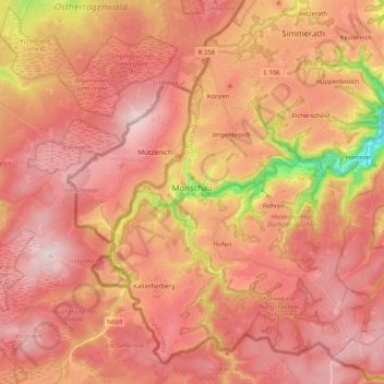
Name: Montjoie topographic map, elevation, terrain.
Average elevation: 551 m
Minimum elevation: 307 m
Maximum elevation: 669 m
Montjoie (allemand. Monschau) est une ville d'Allemagne occidentale, située au sud d'Aix-la-Chapelle (Région urbaine d'Aix-la-Chapelle), et en bordure du plateau des Hautes Fagnes. La superficie de la commune est de 94,61 km2, pour une altitude comprise entre 350 à 650 mètres.
Other topographic maps
Click on a map to view its topography, its elevation and its terrain.
Loverich
Allemagne > Rhénanie-du-Nord-Westphalie > Région urbaine d'Aix-la-Chapelle > Baesweiler
Loverich, Puffendorf, Baesweiler, Région urbaine d'Aix-la-Chapelle, Rhénanie-du-Nord-Westphalie, Allemagne
Average elevation: 113 m
Aix-la-Chapelle
Allemagne > Rhénanie-du-Nord-Westphalie > Région urbaine d'Aix-la-Chapelle
Aix-la-Chapelle, Région urbaine d'Aix-la-Chapelle, Rhénanie-du-Nord-Westphalie, Allemagne
Average elevation: 225 m
Dorff
Allemagne > Rhénanie-du-Nord-Westphalie > Région urbaine d'Aix-la-Chapelle > Stolberg
Dorff, Stolberg, Région urbaine d'Aix-la-Chapelle, Rhénanie-du-Nord-Westphalie, 52223, Allemagne
Average elevation: 254 m
Stolberg
Allemagne > Rhénanie-du-Nord-Westphalie > Région urbaine d'Aix-la-Chapelle
Stolberg, Région urbaine d'Aix-la-Chapelle, Rhénanie-du-Nord-Westphalie, Allemagne
Average elevation: 266 m