
Town of West Turin topographic map
Interactive map
Click on the map to display elevation.
About this map
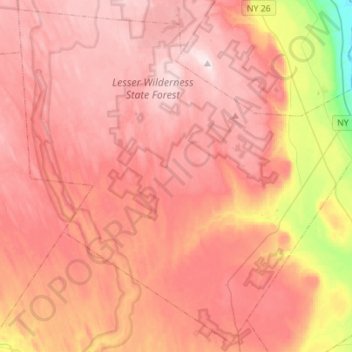
Name: Town of West Turin topographic map, elevation, terrain.
Average elevation: 501 m
Minimum elevation: 222 m
Maximum elevation: 644 m
West Turin has a warm-summer humid continental climate (Dfb). Winter is cold and very snowy, with most days not making it to freezing. Snow can fall anytime from October to May, and a consistent snowpack is expected from November to April. Due to its elevation, it is one of the coldest, snowiest, and wettest places in the state. Summer is warm during the day, but it cools off quickly at night. While West Turin is very wet year round, spring is the driest time of year with 3 to 5 inches (76 to 127 mm) of rain per month, while fall is the wettest time of year with 5 to 6 inches (130 to 150 mm) per month.
Other topographic maps
Click on a map to view its topography, its elevation and its terrain.
Town of Lowville
United States > New York > Lewis County
Town of Lowville, Lewis County, New York, 13367, United States
Average elevation: 289 m
Harrisville
United States > New York > Lewis County
Harrisville, Town of Diana, Lewis County, New York, United States
Average elevation: 250 m
Brantingham Lake
United States > New York > Lewis County > Town of Greig
Brantingham Lake, Town of Greig, Lewis County, New York, 13312, United States
Average elevation: 384 m
Village of Lyons Falls
United States > New York > Lewis County
Village of Lyons Falls, Town of West Turin, Lewis County, New York, United States
Average elevation: 268 m
Town of New Bremen
United States > New York > Lewis County
Town of New Bremen, Lewis County, New York, United States
Average elevation: 282 m
Beaver River
United States > New York > Lewis County > Town of Croghan > Village of Croghan
Beaver River, Village of Croghan, Town of Croghan, Lewis County, New York, 13305, United States
Average elevation: 256 m
Village of Castorland
United States > New York > Lewis County > Town of Denmark
Village of Castorland, Town of Denmark, Lewis County, New York, United States
Average elevation: 233 m
Town of Leyden
United States > New York > Lewis County
Town of Leyden, Lewis County, New York, United States
Average elevation: 397 m
Town of Lewis
United States > New York > Lewis County
Town of Lewis, Lewis County, New York, 13489, United States
Average elevation: 458 m
Montague
United States > New York > Lewis County
Montague, Lewis County, New York, United States
Average elevation: 470 m
Town of Pinckney
United States > New York > Lewis County
Town of Pinckney, Lewis County, New York, 13626, United States
Average elevation: 441 m
Beartown State Forest
United States > New York > Lewis County > Town of Croghan
Beartown State Forest, Town of Croghan, Town of Wilna, Lewis County, New York, United States
Average elevation: 268 m
Brantingham
United States > New York > Lewis County > Brantingham
Brantingham, Greig, Lewis County, New York, 13345, United States
Average elevation: 381 m
Belfort
United States > New York > Lewis County > Belfort
Belfort, Lewis County, New York, 13327, United States
Average elevation: 312 m
Boonville Forest Preserve Detached Parcel
United States > New York > Lewis County
Boonville Forest Preserve Detached Parcel, Town of Boonville, Lewis County, New York, United States
Average elevation: 355 m
Pleasant Lake
United States > New York > Lewis County > Brantingham
Pleasant Lake, Brantingham, Lewis County, New York, United States
Average elevation: 384 m
Village of Lowville
United States > New York > Lewis County
Village of Lowville, Town of Lowville, Lewis County, New York, United States
Average elevation: 285 m