
Archita topographic map
Interactive map
Click on the map to display elevation.
About this map
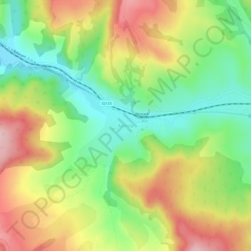
Name: Archita topographic map, elevation, terrain.
Location: Archita, Vânători, Mureș, 547636, Roumanie (46.16069 25.06722 46.20069 25.10722)
Average elevation: 552 m
Minimum elevation: 445 m
Maximum elevation: 684 m
Other topographic maps
Click on a map to view its topography, its elevation and its terrain.
Sighișoara
Roumanie > Mureș > Sighișoara > Sighișoara
Sighișoara, Mureș, Roumanie
Average elevation: 422 m
Gheorghe Doja
Gheorghe Doja, Zona Metropolitană Târgu Mureș, Mureș, Roumanie
Average elevation: 360 m
Târgu Mureș
Târgu Mureș, Zona Metropolitană Târgu Mureș, Mureș, Roumanie
Average elevation: 357 m