
Make a donation
Gear up for your next adventure:
As an Amazon Associate, this site earns from qualifying purchases at no extra cost to you.
Schöntal topographic map
Click on the map to display elevation.
Make a donation
Gear up for your next adventure:
As an Amazon Associate, this site earns from qualifying purchases at no extra cost to you.
Schöntal
Schöntal, die Gemeinde mit der größten Fläche im Hohenlohekreis, liegt in Luftlinie rund 15 km westnordwestlich der Kreisstadt Künzelsau und rund 30 km nordöstlich des Regionszentrums Heilbronn. Die größeren Dörfer reihen sich im unteren Tal der Jagst, die die Gemeinde westsüdwestlich durchläuft, oder liegen in den dem Fluss zulaufenden Nebentälern des linken Sindelbachs, dann des rechten Erlenbachs und – erst in einer Nachbargemeinde unterhalb – der ebenfalls rechten Kessach. Auf den Höhen zwischen diesen und einigen Nachbargewässern gibt es nur kleine Siedlungsplätze.
Make a donation
Gear up for your next adventure:
As an Amazon Associate, this site earns from qualifying purchases at no extra cost to you.
About this map
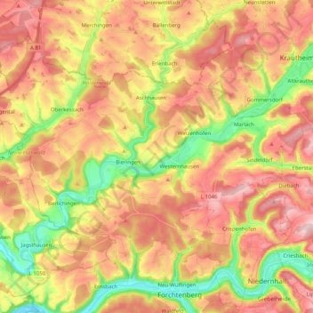
Name: Schöntal topographic map, elevation, terrain.
Location: Schöntal, Hohenlohekreis, Baden-Württemberg, Deutschland (49.29582 9.43989 49.39706 9.63956)
Average elevation: 308 m
Minimum elevation: 182 m
Maximum elevation: 407 m
Make a donation
Gear up for your next adventure:
As an Amazon Associate, this site earns from qualifying purchases at no extra cost to you.
Other topographic maps
Click on a map to view its topography, its elevation and its terrain.
Hohebach
Deutschland > Baden-Württemberg > Hohenlohekreis
Erstmals urkundlich erwähnt wird Hohebach 1238, als Pfarrer Conrad von Hohebach dem Konrad von Krautheim Güter abkauft, um sie der Kirche zum Unterhalt eines ewigen Lichtes zu schenken. Ursprünglich war Hohebach im Besitz der Herren von Krautheim, die Herren von Hohebach saßen als ihre Dienstleute auf dem…
Average elevation: 345 m
Buchhorn
Deutschland > Baden-Württemberg > Hohenlohekreis > Heuberg > Buchhorn
Average elevation: 328 m
Make a donation
Gear up for your next adventure:
As an Amazon Associate, this site earns from qualifying purchases at no extra cost to you.
Öhringen
Deutschland > Baden-Württemberg > Hohenlohekreis > Öhringen > Öhringen
Öhringen liegt im westlichen, tiefer gelegenen Teil der Hohenloher Ebene, zwischen der Keuperstufe der Schwäbisch-Fränkischen Waldberge und dem Kochertal. Die Stadt breitet sich über das flache Tal der Ohrn aus, eines kleinen Flusses, der etwa 10 km talwärts im Stadtteil Ohrnberg in den Kocher mündet.…
Average elevation: 269 m
Make a donation
Gear up for your next adventure:
As an Amazon Associate, this site earns from qualifying purchases at no extra cost to you.
Make a donation
Gear up for your next adventure:
As an Amazon Associate, this site earns from qualifying purchases at no extra cost to you.
Hohe Straße
Deutschland > Baden-Württemberg > Hohenlohekreis > Schöntal > Westernhausen
Average elevation: 325 m
Make a donation
Gear up for your next adventure:
As an Amazon Associate, this site earns from qualifying purchases at no extra cost to you.
Domäne Hohebuch
Deutschland > Baden-Württemberg > Hohenlohekreis > Waldenburg
Average elevation: 357 m
Make a donation
Gear up for your next adventure:
As an Amazon Associate, this site earns from qualifying purchases at no extra cost to you.
Make a donation
Gear up for your next adventure:
As an Amazon Associate, this site earns from qualifying purchases at no extra cost to you.
Hofratsmühle
Deutschland > Baden-Württemberg > Hohenlohekreis > Künzelsau > Garnberg
Average elevation: 345 m
Make a donation
Gear up for your next adventure:
As an Amazon Associate, this site earns from qualifying purchases at no extra cost to you.
Neufelser Mühle
Deutschland > Baden-Württemberg > Hohenlohekreis > Neuenstein
Average elevation: 334 m
Unterhof
Deutschland > Baden-Württemberg > Hohenlohekreis > Künzelsau > Gaisbach
Average elevation: 362 m
Gewerbepark Hohenlohe
Deutschland > Baden-Württemberg > Hohenlohekreis > Waldenburg
Average elevation: 359 m
Make a donation
Gear up for your next adventure:
As an Amazon Associate, this site earns from qualifying purchases at no extra cost to you.
Löhleinsberg
Deutschland > Baden-Württemberg > Hohenlohekreis > Hollenbach > Löhleinsberg
Average elevation: 377 m
Make a donation
Gear up for your next adventure:
As an Amazon Associate, this site earns from qualifying purchases at no extra cost to you.
Make a donation
Gear up for your next adventure:
As an Amazon Associate, this site earns from qualifying purchases at no extra cost to you.
Obersöllbach
Deutschland > Baden-Württemberg > Hohenlohekreis > Neuenstein > Obersöllbach
Average elevation: 301 m
Make a donation
Gear up for your next adventure:
As an Amazon Associate, this site earns from qualifying purchases at no extra cost to you.
Eichelshof
Deutschland > Baden-Württemberg > Hohenlohekreis > Schöntal > Eichelshof
Average elevation: 307 m
Make a donation
Gear up for your next adventure:
As an Amazon Associate, this site earns from qualifying purchases at no extra cost to you.
Make a donation
Gear up for your next adventure:
As an Amazon Associate, this site earns from qualifying purchases at no extra cost to you.