Geolocate

information;Ganda topographic map

Click on the map to display elevation.

About this map

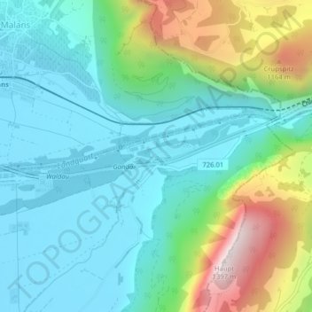
Name: information;Ganda topographic map, elevation, terrain.

Location: information;Ganda, Igis, Landquart, Grisons, 7208, Switzerland (46.96076 9.58395 46.98076 9.60395)

Average elevation: 744 m

Minimum elevation: 531 m

Maximum elevation: 1,363 m

Gear up for your next adventure:

🛶Kayak Accessories - Essential gear for safe and fun kayaking adventures
🧥Thermal Layer - Insulating layer for cold outdoor conditions
🥾Trekking Boots - Durable boots for long-distance trekking
🥾Approach Boots - Comfortable boots for hiking and climbing approaches
🔥Camping Stove - Portable stoves to cook outdoors with ease

As an Amazon Associate, this site earns from qualifying purchases at no extra cost to you.