Geolocate

Tata topographic map

Click on the map to display elevation.

About this map

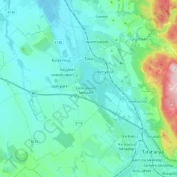
Name: Tata topographic map, elevation, terrain.

Location: Tata, Tatai járás, Komárom-Esztergom, Central Transdanubia, Hungary (47.57710 18.23069 47.68289 18.42203)

Average elevation: 185 m

Minimum elevation: 112 m

Maximum elevation: 558 m

Other topographic maps

Click on a map to view its topography, its elevation and its terrain.

Vértes

Hungary > Komárom-Esztergom

The area of the Vértes occupies 314 km2 (121 sq mi). It is about 30 km long and 10–15 km wide. The average altitude is above sea level is 350 meters; its highest points are 487 m (Nagy-Csákány), 480 m (Körtvélyes) and 479 m (Csóka-hegy). Geologically the Vértes constitute a fairly uniform structure.…

Average elevation: 245 m

Nagysáp

Hungary > Komárom-Esztergom > Nagysáp > Nagysáp

Average elevation: 197 m

Tatabánya

Hungary > Komárom-Esztergom > Tatabánya

Average elevation: 218 m

Gear up for your next adventure:

👟Trail Running Shoes - Agile footwear for fast-paced topographic exploration
🧴First Aid Kit - Essential first aid supplies for outdoor emergencies
🧰Survival Kit - Essential gear for emergencies in the wilderness
🥾Hiking Leggings - Comfortable leggings for outdoor activities
🕯️Camping Lantern - Illuminates your entire campsite with high-efficiency LEDs

As an Amazon Associate, this site earns from qualifying purchases at no extra cost to you.